Thursday, August 30, 2012

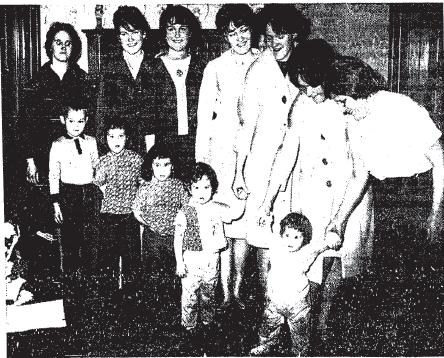
The Ten O'Neil Sisters


The O'Neil sisters, April 22, 1946.


Mrs O'Neil, daughters and grandkids, April 13, 1963.


Three O'Neil sisters return to parade with sons and daughters, April 6, 1980.


There was a time when big families were common in Boston. And when I say big, I mean twelve children, including ten girls. That was the O'Neil family of Wyman street, Jamaica Plain during the 1940s and 50s. They were a staple at the annual Easter Parade in their identical outfits, and of course were favorites of newspaper photographers and editors.


The Ten O'Neil Sisters Home Page

Wednesday, August 22, 2012

No Love For The EL

It took over forty years, but they finally got rid of the Forest Hills elevated line. There were multiple efforts to take down the elevated structure in the 1940s. In this case, a city councilor tried to use the war effort to justify his attempt. Personally, it never occurred to me during the 1960s that the El would be taken down. I looked at it as an essential service, like a water main. Of course, I didn't live under the damn thing.

The claim that the El ran parallel to the New York New Haven line was disingenuous. Roxbury and the South End have suffered from the Orange Line move west to the railroad bed, and residents have been demanding a replacement ever since. For Jamaica Plain, on the other hand, it was a great deal.


Daily Boston Globe April 14, 1942

Demolition of 'El' From Forest Hills to Broadway is Urged


Demolition of the Elevated structure from Forest Hills to Broadway, thereby making available hundreds of thousands of tons of steel for the national war effort, was recommended by the Boston City Council at yesterday's session.

City Councilor James M. Langan of Jamaica Plain, who introduced the order, pointed out that the New York, New Haven and Hartford Railroad runs almost parallel to the Boston Elevated structure from Forest Hills to the Back Bay Station and that the "L" could use the abandoned rails of this railroad, inasmuch as they are of the same gauge.

Pres. Thomas E. Linehan appointed a committee comprising Councilor Langan, Councilor Thomas J. Hannon of Dorchester, and Councilor William F. Hurley of Roxbury to confer with Mayor Tobin and officials of the El relative to the advisability of razing the El structure.

Friday, June 29, 2012

A Tree is Planted on Arbor Day

Eliot School, Arbor Day tulip tree on left (photo by Charlie Rosenberg).


The schoolboy tulip tree, shown at its full height (photo by Charlie Rosenberg).


I considered posting this entry for Arbor Day, but there would have been no leaves on the tree in April, and it seemed a shame to show the tree without its leaves. The article below describes a tree planting by boys from the Agassiz school in 1928. Mayor Nichols lived right at the Monument at the time, and sent his boys to the Agassiz. Professor Robert H. Richards lived at the corner of Eliot and Dane streets, and was the husband of Ellen Swallow Richards, chemist and first woman granted a degree from M.I.T. The article doesn't say, but Professor Richards, then retired from M.I.T., was at the time running the Eliot School. The Arnold Arboretum got involved by donating the tree in the name of their former director. Given the roles played by three institutions, the Agassiz, the Eliot school, and the Arboretum, plus a resident mayor and his sons, plus a resident member of M.I.T.'s first graduating class, it might be nice if a small plaque could be put on the tree commemorating the Arbor Day planting. That's a lot of history for one tulip tree.


Daily Boston Globe April 28, 1928


Trees Planted By Pupils Of Boston's Public Schools


To children attending Boston schools yesterday was Arbor Day. The official observance throughout the state will be today, but schools will be closed, so appropriate exercises were held yesterday.

*********************************************

In Jamaica Plain, Mayor Nichols watched his two sons, Clark and Dexter, and the sixth grade boys in the mechanic arts course of the Agassiz School plant a tulip tree in memory of Charles Sprague Sargent, late director of the Arnold Arboretum. Clark is in the fifth and Dexter in the fourth grade at the Agassiz School.

The tree, a gift of the Arboretum, was planted in front of the Eliot School on Eliot st, an annex of the Agassiz, where the boys go for their carpentry and garden work. Others who attended the planting included Mrs Nichols, Prof Robert H. Richards, formerly of the Massachusetts Institute of Technology, who allowed the tree to be planted on his grounds, now rented to the city; William H. Judd, propagator of the Arboretum, who told about its work, and Joseph Q. Litchfield, master of the Agassiz School district.

The other boys who took part in the actual planting were David Shepard, David Crew, William McDonough, George Muise and James Reynolds. John Ryan read Gov Fuller's Arbor Day proclamation and John Spence was master of ceremonies. A group of eight boys recited stanzas of "Trees of the Fragrant Forest."

Thanks for Charlie Rosenberg for the photos. You can read about Ellen Swallow Richards at the Jamaica Plain Historical Society web site.

Sunday, May 27, 2012

Walk Around The Pond - And Help the Library

Curling on Jamaica Pond, 1890s.


Saturday, June 2, from 1:00 PM to 4:00 PM, there will be a Walk Around the Pond fundraiser for the Jamaica Plain and Connolly branch libraries in Jamaica Plain. Suggested donation is $5, and registration will be at the boathouse. Come out and support the libraries that have done so much for Jamaica Plain residents over the years. Be there or be square.

Tuesday, May 15, 2012

Jamaica Towers

Perkins street and the Jamaicaway, 1905.

[Update: a reader has informed me that the correct name of the property is Jamaicaway Tower and Townhouses. Since I've known it all my life as Jamaica Towers, I'll leave my original language in the text and stand corrected in fact.]

Henry Rueter, brewer and partner in the Highland Spring Brewery at Heath and Parker streets, lived at the corner of Perkins street and the then-new Jamaicaway. Notice the other adjacent homes, each on a substantial lot, including carriage houses.


The appropriately named Jamaica Towers rises above the Emerald Necklace, providing its inhabitants wonderful views, while making a sore thumb of itself for those availing themselves of the adjacent parkland. The article transcribed below describes one minor speed bump along the way to the developers making their money and the residents gaining their views. Interesting to note was the involvement of the BRA in declaring the property as 'blighted.' Nice trick, that. Somehow, I doubt they'd get away with it today. Note below that there is no mention of Olmsted's Emerald Necklace.


Boston Globe June 12, 1964

Hearing on High-Rise Apts.

Jamaicaway Plan Stirs Row


One Jamaica Plain resident Thursday referred to a vacant piece of land along the Jamaicaway as a "glamorous dump" as he supported a plan for a high rise apartment building on the site while a neighbor termed the proposed development "a monstrosity."

The debate for and against the $7 million development at Perkins st. was focused on a Boston City Council hearing to determine whether state legislation limited building heights to 65 feet along the Jamaicaway should be accepted.

Only 65 residents attended the hearing along with some legislators, with 12 voicing support for the high rise plan and an equal number speaking against it. But both sides claimed the support of hundreds of other residents and petitions with lists of signatures were entered into the records.

The state legislation was initiated by both State Sen. James Hennigan of Jamaica Plain and State Rep. William Carey to block the luxury apartment development planned by educator and economist Arnold Soloway and several otter principals under a limited dividend corporation.

"There has been a bill of goods sold out there by the real estate people," said Carey, referring to petitions gathered by residents in support of the plan.

He had support from Sen. Hennigan who said he objected to the designation put on the vacant area by the Boston Redevelopment Authority as "blighted," and from State Rep. Charles R. Doyle of West Roxbury who declared that property values of existing homes in the area would decrease because of the high rise structure.

In sharp disagreement were State Rep. Stephen C. Davenport of Jamaica Plain and State Rep. James Kelly of Roxbury.

"It is hard to imagine a poorer piece of legislation," said Davenport, "that's a violation of home rule."

Kelly said an investment of $7 million "is good for Jamaica Plain." He declared his office is close to the location and no one has called him to say they opposed the high rise plan.

Dr Elizabeth Kleiman of 66 Perkins st. opposing the high rise, said it should be closer to the city. Atty. John J. Walsh of 15 Pondview av. urged the council to "repudiate" the plan.

Soloway said his group is contemplating a 282-unit, 29-story building which because of the sloping nature of the land area, would not be visible from adjacent areas and would not obstruct any abuttors since it occupies only six percent of the land area. He projected rentals at from $130 to $450 - the latter for four duplex penthouses. He said the firm also is considering a shuttle service for residents to downtown areas to encourage people to leave their cars at home.

Thursday, May 10, 2012

The Hodgdon House

Jamaica Pond at the top. South, Walk Hill and Back (now Morton and the Arborway) streets meet near the Dedham Turnpike and the 'J' in Jamaica Plains (sic), 1819 (BPL). The small black box at the intersection of South and Walk Hill streets is the Hodgdon house discussed below. The Turnpike tollgate is somewhere near Walk Hill street.

Abram Hodgdon was born circa 1801. He married Emily Ayers on Christmas day, 1825, and a second time to Elizabeth Holmbert in 1845. The Norfolk County Registry of Deeds holds contracts for Hodgdon to build houses, as well as a trustee's notification of property being sold off to pay his debts. In the graveyard at the back of the Unitarian church at Centre and Eliot streets, there is a monument with the inscription "Sacred to the memory of MRS EMILY, wife of Abram Hodgdon, who died April 7, 1843."

In September of 1827, Abram Hodgdon bought four acres of land sitting between 'the road to Walk hill,' 'the lower road to Dedham' (South street), and Stony river (brook), a house and a barn for $333. Further search shows that 'a barn and half a house' were on the site already in 1806. Whether this was part of the eventual 'Hodgdon house' is a matter of conjecture, but it seems reasonable that it was.


South and Walk Hill streets, 1859 (BPL). The railroad now runs through the neighborhood. The house is again shown where South and Walk Hill street meet. Back street is now called Forest Hills street where it meets South street.


The 1908 article from the Boston Globe transcribed below tells of the demolition of an old house, once owned by the above Abram Hodgdon. The house sat along South street, between what is now Forest Hills station and the State Laboratory property. The old intersection has changed dramatically since then. Going back to the Colonial era, there was no Washington street, no Hyde Park avenue and no Arborway. Near what is now Forest Hills, a crossroads of sorts was located. South street (then the lower road to Dedham), met the road to Walk hill (also known as the road to Lower Mills, on the Dorchester/Milton line) and Back street (a continuation of Roxbury's Walnut avenue).

This intersection that was home to the Hodgdon house was where South street now turns towards the Arnold Arboretum across from the Forest Hills T station. Th end of Walk Hill street that once met South street was cut off when the railroad tracks were raised on a granite-walled embankment in the 1890s. Within ten years, the Hodgdon house was demolished for an apartment complex that remained until the 1960s.


Arborway Court at South street and the Arborway, 1924. The intersection has changed, but South street still comes through, and Walk Hill street is now the very short St Ann street. The house is gone, replaced by a brick apartment complex overlooking the railroad station and the Forest Hills elevated station.


Boston Daily Globe October 18, 1908

Landmark Is Razed

Old Hodgdon House in Forest Hills Was Built About 1812

Big Apartment House on Site


The march of improvement in the Forest Hills section has made necessary the demolition of one of the old landmarks that has stood for nearly 100 years at the junction of South and Walkhill (sic) sts, and the Arborway, and was known as the old Hodgdon house.

Recently the lot of land on which it stood was purchased by New York parties and the old-fashioned dwelling is to make room for a large modern apartment house of four stories and will contain 72 apartments.

The house has been almost completely demolished. The workmen in tearing it down, found an old-fashioned carpenter's square, of wood and tin and nearly two feet in length on its longest side.

The original building, it is said, was erected about the time of the war of 1812. It is evident that there were three distinct sections to the building, built at different times.

The frame was of hewed oak and the floor boards were of clear pine, some two feet in width. Three outside walls were bricked between the studding, the bricks being laid in cement.

The nails used in the construction of the original house were hand forged, as were the larger spikes used fastening the heavy frame work,

The house was a two-story, hip roof, containing eight rooms with unfinished attics. At some time a new roof was put in place and a portion of the old roof, with the shingles on it, was found still in place.

In the old days before the railroad was constructed at the foot of the hill on which the old dwelling stood, it was an important cross roads residence.


Source: Norfolk Country Registry of Deeds, 83:219 9/22/1827 Jonathan Trull to Abram Hodgdon.

Monday, April 16, 2012

The Daniel Nason, and a Cool Carriage


This locomotive is the Daniel Nason , built in 1858 for the Boston & Providence railroad line, and now on display at the St Louis Museum of Transportation. She's a wood-fired locomotive designed by George S. Griggs and built at the Roxbury shop just north of Ruggles street, on land now home to Northeastern University. Daniel Nason himself was the Superintendent of Transportation at the Boston depot of the Boston & Providence line. If you lived in Jamaica Plain in the following years, you would have seen the Daniel Nason chugging through the community, and perhaps it would have taken you to Boston to work or shop.


This carriage was found at the back end of the Boston & Providence Roxbury repair shop in the 1890s and refurbished for display. It was reportedly imported from England, and is now in the hands of the St Louis Museum of Transportation. Is this one of the earliest railroad passenger carriages in existence? It looks like a horse carriage dropped on to rail wheels. Which would make sense, given that a horse carriage was the only model they had, and early locomotives were small, slow-moving vehicles.

I was puzzled at first by the presence of what appears to be footrests on the top front and back of the car. Would a railroad car have footrests for a driver? Then, I found this image:


Here we have a photograph of a very early locomotive and two passenger cars that are very similar to the one shown above. And this explains the footrests - people sitting on the roof!


And finally, this 1849 map fragment shows the Boston & Providence and Boston & Worcester lines crossing in the Back bay. Notice the cars - short, with three windows each. While the drawing was only intended to indicate a railroad line on the map, the artist/cartographer would have modeled his drawing on real trains, and the carriages here bear a close resemblance to the one shown above.


For more on the Roxbury locomotive works and George Griggs, master mechnic of the shop, check out this co-post on my Boston blog here.

Friday, April 6, 2012

Here Comes the Wrecking Ball

I've been asked to publicize a meeting being held to discuss the possible demolition of the New England Home for Little Wanderers building on South Huntington avenue. You can read about it in the Jamaica Plain Gazette. To add some color, I've reposted an earlier entry from this blog.


Here's another South Huntington avenue institution. The New England Home for Little Wanderers was founded in 1865, and moved to the edge of Jamaica Plain as described in this article. For some reason, this region of Roxbury/Jamaica Plain was quite popular with charitable institutions, as shown in earlier entries. I added a contemporary picture below.


Boston Daily Globe July 28, 1914


Little Wanderers' $100,000 Building New Location for Home for Destitute Children. Work on the Erection of a Flameproof Structure Has Begun.


The New England Home for Little Wanderers will sell its present location at 202 West Newton st, and has begun to erect a new structure at a cost of $100,000 between the Jamaicaway and South Huntington av, about four miles from the Public Library and near the spots now occupied by the Boston Nursery for Blind Babies and St Vincent's Hospital. The grounds will comprise about six acres.

The plan of moving has been under consideration for some months, but negotiations for the actual construction have only just been completed.

The architects of the new institution are Brainerd(sp) & Leeds. The building will be fireproof, of three stories and a basement. The ground floor will contain the great dining room for the children, the kitchen and allied features. The boiler plant will be outside the building, its roof forming a terrace.

The first floor will hold a large auditorium with a capacity of 180, suitable for conventions held in the building. There will also be administration rooms for the superintendent, matrons, directors, etc.

The second floor will provide for the occupancy of from 40 to 50 children - rather fewer than the present building, because the plan is that the outside department henceforth shall be of more importance than the actual administrative department.

About 1000 inmates pass through the institution in the course of a year, the most detailed record of them being kept after they pass from beneath the roof of the building to homes elsewhere.

The third floor will be for a playroom and a hospital. The basement will be of reinforced concrete and the material of the remainder of the building will be of antique brick with a considerable amount of stone trimmings, the whole presenting an appearance of the Colonial period. It is hoped the new building may be ready for occupancy by next Spring.

The institution was organized in Boston in May, 1865, under a charter granted by the Legislature of Massachusetts for the purpose "of rescuing children from want and shame, providing them with food and clothing, giving them instruction in mind and heart and placing them, with the consent of their parents, or guardians in Christian homes."

Homeless and destitute children are received from all parts of New England. No discrimination is made because of color, race, sex or religion.

Arthur S Johnson is president of the Home; Samuel D. Parker, treasurer, and Frederic D. Fuller, secretary. The superintendent is Rev F.H. Knight.

The Home is a private charity. It is not supported by State, city or town funds, but by legacies and contributions from churches and individuals.


January, 2008

Monday, April 2, 2012

Ye Olde Forest Hills Station


This 1908 article discusses the then-new Forest Hills elevated station. The drawing above shows an open, fenced-in ground floor. It did get closed in quite a bit more than that on the sides. Notice the water fountain in the middle of the road. And notice the style of writing in the article. It content comes out sounding like a P.R. release, but they style is very different from anything we'd read in a newspaper today. They had not yet received the cut, cut cut message, so they weren't mean with their words.


Boston Daily Globe March 23, 1908

Hope To Have work Done This Year

Building of the Elevated Station in Forest Hills Sq Has Commenced - The Platform Arrangement.


After a prolonged disagreement over the location of the Forest Hills terminal of the elevated railroad, ground has at last been broken in Forest Hills sq. and the work of putting in the foundations for the new station begun.

The abrupt termination of the elevated structure at the entrance of the square, with its big derricks overhanging the roadway, has long been an annoyance to the residents of the district, and the completion of the work is looked forward to by all.

The terminal will be located on the west side of the square, adjoining the NY, NH & H tracks, and will be 360 feet long by 70 feet wide - a much larger station than the present terminal at Dudley st. Two tracks will pass through the station, one inbound and the other outbound.

There being no loop as at Dudley st, a blind end will be used; that is, the tracks will extend beyond the station far enough for a train that has unloaded its passengers from Boston to run out and switch over to the inbound track, when it will return to the station and load passengers for Boston from an opposite platform.

Egress from the unloading platform of the station to the surface car loading platform will be by means of two stairways. Passengers arriving on surface cars and bound for Boston will alight on an opposite platform and will gain access
to the elevated loading platform by means of two moving stairways and two ordinary stairways. Both surface car platforms will be enclosed by fences as is the case now at Dudley st.

The elevated platforms will be large enough to accommodate any crowds that will have occasion to use them for some years to come, the loading platform being 30 feet wide and the unloading platform will have a width of 20 feet, while their great length of 360 feet will amply accommodate an eight-car train, as will all of the new elevated stations and those on the Washington-st subway.

The material used in the construction of the new station and that portion of the elevated structure which crosses the arborway will be reinforced concrete, and the architecture of the whole will be sufficiently ornate to be in keeping with the surroundings, the portion of the elevated structure previously mentioned being somewhat similar in design to the present railroad bridge over the arborway.

The northern end of the station, which might be called the front entrance, will be somewhat higher than the rest of the building and will be 64 feet high. In that portion of the building will be located a waiting room, toilet rooms and an office.

With the completion of this station the Dudley-st station will cease to be a terminal and become a way station, and to this end important changes are to be made there.

No definite arrangements have yet been made by the elevated officials for handling the traffic under the new conditions, but in all probability some of the surface car line which now feed Dudley-st station will be diverted to one of the new elevated stations, possibly that at Egleston Square, thus relieving the Dudley-st station of a great deal of congestion. The engineers hope, with good fortune, to be able to complete the work by the end of this year, when, with the completion of the new subway, Boston will have taken a long stride in the direction of real rapid transit.

Monday, March 26, 2012

The May House - En-Castle-ated

Detail of room in old wing of the May house.


Known as the Arborway Castle, or alternately as the house with all those fr*&%$in' Christmas lights, the May house joins the Curtis house in our parade of modified-to-the-point-of-unrecognizability Colonial houses. As is common with such articles, there is questionable information in this one. The writer states that the modern 'castle' part of the house was added to the original Colonial house in the 1800s. To be more precise, the addition was built between 1896 and 1904. It states that the house was built by a Mr Bridge. Bridge did sell the land to the Mays, but I'm not sure we can be confident that this was the original Bridge homestead. There were other houses on May's lane owned by the Mays in the late 1800s, any one of which could have been the oldest. And of course, the original house may have been torn down and replaced during the Colonial era. The Curtis house recently discussed here is dated to 1722, so it, too could be the oldest in the community.


Daily Boston Globe February 15, 1937

Jamaica Plain House Sold, Recalls Colonial History


The house of a thousand daily conjectures, strange in its location and imposing with its turreted, castle-like architectural appointments, has opened its portals and revealed an historical secret - the remnants of the Colonial home of Capt John May.

The unusual structure, located at 61 Arborway, Jamaica Plain, a short distance from Jamaica Pond on a main highway artery, has been viewed by passing motorists who wondered at its age and history.

For many years it has been tightly closed, but will now have an occupant, James M. Graham, Boston attorney, who purchased the property, known as the May and later Carter estate, from Mrs. John Emmons, Hingham, through the real estate office of the MacLellan Brothers.

In the passing of papers it was revealed that 11 "modern" rooms of the "castle" had been constructed in the 1800s, around five of the rooms of the old May house, which was built on May's lane, now May st, by a a Mr Bridge in 1650.

The first John May, master of the vessel (?), came from Mayfield in Sussex, England, and became a resident of Jamaica Plain and the ancestor of many of bear the name of May in this country. The original home was known in later years as the May House, after Capt Lemuel May, who fought in the Battle of Lexington and whose grave is in the little churchyard of the First Congregational Church on Eliot st, Jamaica Plain.

The five rooms represent what was probably the oldest house in Jamaica Plain. There were originally 47 acres on the May farm, but with the expansion of the park system about one-third of the area was taken. When part of the old house was razed incident to the erection of the present structure by Thomas W. Carter, workmen found a number of relics of Colonial years.

They included pewter spoons, buttons from the uniforms of the "Minute Men of 1775" and a number of silver coins. Spanish silver coins were plowed in the land adjacent to the house.

The old section of the property contains the original hardware of the Revolutionary period and the figures 1760 can still be seen on the fire back in the old fireplace.

Entering from the front porch there is a small, square reception hall that opens through narrow doorways into the old low-studded,irregular shaped rooms that have corner beams and wooden fittings of rich quartered oak.

The old living room with its hand-hewn ceiling beams, wainscotted sides, corner cupboard with convenient little shelves bears a distince Colonial tinge even though the woodwork has been covered with enameled paint. The old wooden coat hangers are in evidence and the beautiful hand-carved wooden staircase has a spiral carved newel post and uprights.

It is said that the house was used as a barracks durign the siege of Boston. On July 4, 1901, long after the present structure was erected, Capt Richmond P Hobson, United States Navy; Admiral Sampson and Boston Mayor Hart were entertained there.