The toll-house referred to below was in today's Forest Hills, where you paid to use the turnpike - now Washington street. The turnpike had only been there for about twenty years at this time, and someone may have been driving their cows through on their way to market when one wandered off.
I think it would be nice to return the toll gate name to Forest Hills in some manner. Forest Hills was first applied to the cemetery, and was an early version of those rural names used to entice suburbanites into a new housing developments.
Boston Intelligencer, March 21, 1818
Taken up,
On the 6th inst. by the subscriber, a small brindle COW. The owner may have her by paying charges, and applying to JOSEPH M. WELD, near the toll-house on the Dedham Turnpike, Jamaica Plain.
march 21
Wednesday, December 31, 2008
Monday, December 29, 2008
The Boston Weed
I've added a new slide show - three decker houses. Jamaica Plain didn't get the mass of similar three deckers that Dorchester did, and there is much variety represented in the Jamaica Plain buildings. Some are double three deckers - six unit buildings - and others have been ornamented with Italianate or Queen Anne elements. There are even brick versions. Three deckers - the "Boston Weed" - were the scourge of certain "reformers," the cause of fire and disease. Of course, those reformers didn't live in such buildings, and never thought to ask the residents their opinions. Truth be told, they were highly efficient in their use of available land, they allowed resident children a yard in which to play, served as an entry into the housing market for the working class, and their standard floor plans made for quick and inexpensive construction. The more elaborate "dandified" three unit houses could hardly be called tenements, and allowed builders and owners to set themselves off from the common three decker box. All in all, a design for Boston to be proud of.
Thursday, December 25, 2008
Happy Holidays
For anyone full of Christmas dinner and looking for something to do on the internet, I've tagged some past entries with the Christmas label. There are some cute stories about Christmas past in there. Enjoy, and Merry Christmas to you.
Saturday, December 20, 2008
The Old Homestead
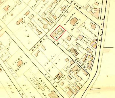 Brewer street, 1874 (JP Historical Society).
For many people, an interest in local history starts with their own home. I lived in four houses in Jamaica Plain, but I spent my formative years at number 4 Brewer street, between Centre street and Jamaica Pond. The earliest property map showing plot ownership is from 1874, and shows an A. Clough in possession of both 4 Brewer street and the adjacent 25 Thomas street, at the corner of Brewer and Thomas (highlighted in red above). Luckily, we have an 1873 Jamaica Plain/West Roxbury directory available online, which tells me that Alexander P. Clough was the proprietor of a billiards-room, and lived at the corner of Thomas and Brewer streets - that being the house that still stands at 25 Thomas street. The Boston Directory of 1875 lists Alexander P. Clough, restaurant, Centre, corner Burroughs, home, Thomas, corner Brewer, Jamaica Plain. The 1885 Boston Directory lists Alexander B. Clough [son of Alexander P.?], designer, 70 Franklin, bds. Thomas, cor. Brewer, J. P.

This tells me something about the property, but not the house I grew up in. The house shown above is smaller than the one present today, and the footprint of the building is different from the present one as well. More information came from the City of Boston building permit archive. Here (on the right - click to read), we find the building permit application for the present house, submitted in 1897 by owner R.S. Barrow. Mr. Barrows was a real estate agent-turned newspaper publisher, and father-in-law of Robert T. Fowler, the first "Ask Mr. Fowler," real estate agent and founder of the business that still exists on Centre street today. The owner listed on the map below is William J. Miller, who may have provided the mortgage to Mr. Barrows.
 The "new" house at 4 Brewer street, beside the Agassiz School, 1905 (Boston Atlas).
The above information was all available on the Internet, and thus was just a matter of pointing and clicking. One more online map, this one from 1859, represents buildings drawn in as small squares, and shows a house at the corner of Thomas and Brewer and Thomas streets - the Clough house - but nothing at the location of 4 Brewer street. To go back in time and learn more about the history of the property, I had to do some old-fashioned "real world" research.
 Same location, 1859 (Walling, H.F. - BPL).
Previous to 1874, Jamaica Plain was part of the Town of West Roxbury, and thus part of Norfolk County. This allowed me to search through property deeds at the Norfolk Registry in Dedham, rather than going in to downtown Boston. The information that follows didn't come about from a dedicated search of the 4 Brewer property, but rather from various strands of research coming together and pointing back at my old home. The loose ends that I happened upon inspired me to finish the job (at least to some degree) and write it up.
When I looked up the name Alexander Clough in the index of deeds, I found that it was his wife, Martha Ann Clough, who the buyer of the two house lots highlighted in red on the 1874 map above. In March of 1865, Mrs. Clough paid the trustees of the Eliot school the sum of $3000 for 8,100 square fee of land bordered by Thomas street, Brewer street, land owned by the Town of West Roxbury for a school (then the Central grammar school) and the land of Timothy Johnson, (who shows up on Thomas street on the 1874 and 1905 maps above). The deed states explicitly that Mrs Clough owned the land for "her sole and separate use, free from the interference and control of her husband." Such stipulations occur occasionally during the 1800s, and show that women did have some independence from their husbands, at least when they had money of their own to spend. The deed contained a restriction that for 20 years, there could be no bowling alley or public billiards tables, nor intoxicating liquors served on the premises. The deed also required that Isaac Jacobs, tenant in the house at 25 Thomas street, should be allowed to stay in the house until May of the same year. The restriction on billiards is interesting, because as we saw earlier, Mr. Clough ran a billiards room on the corner of Centre and Burroughs streets. In 1866, a year after his wife bought the Brewer street land and house, Alexander entered a five year lease for the building on Centre street from Mary May, widow of Lemuel and mother of Benjamin May. The heirs of Lemuel May owned much of the northeast side of Burroughs street, gradually selling off lots from 1855 on.
At this point, I figured I knew the story. The house I grew up in stood on land owned by the Eliot School trustees, granted by John Eliot, Apostle to the Indians, for support of school. Then, while digging in deeds recording the development of the old Eliot School lands, I learned a fact that spoiled my simple story. Deeds for land along the northeast side of Eliot street (backing on to Burroughs street properties) mention the adjacent lands of Joshua Seaver. A little digging showed me that in April of 1806, Joshua Sever bought six acres from Joseph Lovering, tallow chandler. The 1849 map below shows the approximate boundaries of the Eliot land (in yellow) and the Lovering/Seaver plot (in red).
 Centre street to Jamaica Pond, 1849 (Charles Whitney - BPL).
Much of the old Seaver/Eliot School boundary can still be seen today in existing property lines. Below is a 1924 map, with much of the Seaver/Eliot School boundary highlighted in red along contemporary lines, from Centre street (then still the site of the Seaver family general store) across the Clough lot, Brewer street, and following the back yard division between Eliot and Burroughs street houses. So if my childhood home was part of the Seaver estate in 1806, how was it that the trustees of the Eliot School sold the land (with the next-door plot) to Martha Ann Clough in 1865?
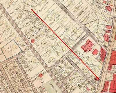 Burroughs and Eliot streets, 1924 (Boston Atlas).
The index books of Grantors (sellers) and Grantees (buyers) tell the story. In 1836, the estate of Joshua Seaver was partitioned among his heirs. By 1841, deeds show actions taken against the estate of J. Seaver, insolvent debtor. A Mr. John A. Eammons sold 47,175 sq. ft of Seaver land (shown in red below on the 1874 map, borders are my best estimate) to John D. Weld for $300. Three years later, Mr Weld sold the land to the Eliot School trustees for $1675.
 Brewer street, 1874 (JP Historical Society)
The blue line shows the border between the original Seaver and Eliot School lands. The red shows the old Seaver land purchased by the school from John D. Weld. So that finally explains how the Eliot School trustees were able to sell the lot I grew up on to Martha Clough. Half of the lot sat at the corner of Brewer and Thomas streets, and had been Eliot School property all along. The other half of the lot - entirely on Brewer street, and beside the Central School in the map above - had been purchased by the Eliot trustees in 1844.
So let's sum up what I learned. The house I grew up in was built on what was, in the early 1800s, a six acre lot running between Burroughs street and the Eliot School land, from Centre street to near today's Agassiz park. Joshua Seaver, whose family ran the village general store for three generations, suffered a financial calamity, and died an insolvent debtor. The family kept part of the Centre street frontage and their store, but the land running up Burroughs street was sold of to satisfy creditors. The trustees of the Eliot school purchased a part of the old Seaver land, including the site of my old house. They sold it to the Cloughs, who built the first house on the site I lived. That house was replaced after 1897 by R.S. Barrows, real estate man and publisher of the local newspaper.
Much of the above information comes straight from the Internet. If I had approached the matter systematically, the deeds could have been chased down at the Norfolk County registry in a day. That just shows you what can be done to learn the history of your own home. Even if you know that the house you live in was built in the twentieth century, the land itself still has a history, and may have much to tell. To go back before the Seaver purchase of the land would require at trip to the Suffolk County registry of deeds, and will have to wait for another day, but I should be able to carry the effort back to the colonial era. All in all, it was well worth the effort to learn about my old home. Or at least one of them - there are three more to go.
Sources:
City of Boston Building Permit Archive.
West Roxbury Directory
Boston City Directories
Norfolk County deeds:
4/2/1806 - 25:109 J. Lovering to J. Seaver
7/24/1841 - 131:245 J. Eammons to J. Weld
5/9/1844 - 146:274 J. Weld to Eliot School trustees
3/22/1865 - 380:267 Eliot Schoot trustees to M.Clough
8/22/1866 - 344:307 Mary May, lease to A. Clough
Thursday, December 11, 2008
A Village Celebration
I found these documents on the Library of Congress web site. They represent the order of performance of the Fourth of July celebration at Jamaica Pond in 1838. It appears as if the Ode sung by the choir was written by David S. Greenough. If the composer was the D.S.Greenough living at the time, he would have been D.S.G. number 3, as both his grandfather and father had passed away by 1830. Next came a poem, written by Samuel G. Goodrich, AKA Peter Parley, who was representing the district in the Legislature at the time, followed by dancing at the Village Hall. The Village Hall Association first leased land on Thomas street from the Trustees of the Eliot School in 1837, so this was the first Fourth of July for the new building. [Correction: after looking at the deeds, I believe the Village Hall referred to here was the building now called Eliot Hall, on Eliot street. The land for the Village Hall on Thomas street was not purchased until later].


Source: Norfolk Registry of Deeds: 115:292 - August 23, 1837.


Source: Norfolk Registry of Deeds: 115:292 - August 23, 1837.
Monday, December 8, 2008
One Hundred Years of Jamaica Plain Architecture
I did a photographic survey of the older houses in Jamaica Plain this year, and I've been looking for something to do with them. Here, I've decided to show the oldest houses with dates taken mostly from the Landmark Commission survey of Jamaica Plain buildings. This is not a comprehensive survey, but a "most information with the least effort" listing. The dates for many houses show a range; for example, "between 1858-1874." The dating was done with maps and directories, so in this case the house doesn't show up in an 1858 directory, but does in an 1874 map. Deeds tell when land was purchased, but not when houses were built, so getting exact dates is impossible in many, if not most cases. The dates come mostly from the Landmark Commission survey of Jamaica Plain buildings that was done in the 1980s - I'll post the reference soon. I've put them in approximate order, with a cutoff of about 1874. Why 1874? It includes all the oldest houses, and leaves the Queen Anne houses for another time. I will be adding houses as I find the time and the energy. The main intent is to allow you to scroll down the page and see how house styles changed over time. Enjoy.
Note: You can see these and many more pictures of pre-20th Century Jamaica Plain houses at the J.P. Historical Society web site here.

Loring-Greenough House - 1760

1085 Centre street - by 1796

526 Centre street - by 1806

812-814 Centre street - between 1802-1810

1090 Centre street - 1820s
 48 Goldsmith street - probably pre-1830; moved from another location.

52 Eliot street - 1822-1843.
 50 Eliot street - between 1822-1843.

991 Centre street - by 1832, possibly 18th century.

1011 Centre street - by 1832.
 1 Dane street - 1833-1834.
 800 Centre street - by 1847
 45R Green street - around 1842.
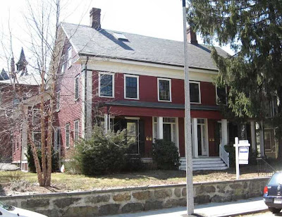 33-35 Green street - 1840-41.
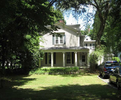 47 Eliot street - by 1843.
 305 Chestnut avenue - 1844-48.

63 May street - 1840s.
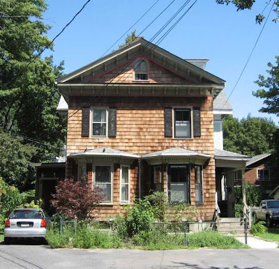 5 Eliot place - between 1843-1854.
 20 Seaverns avenue - 1845-1846.
 18 Seaverns avenue - 1845-1846.
 14 Seaverns avenue - 1840-1845.
 28 Lakeville, between 1842-1845.

317 Lamartine street - between 1843-1858.

28 Cheshire street - between 1849-58.

242 Pond street - between 1849-1859.
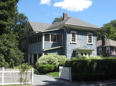 85 May street - between 1848-1859.
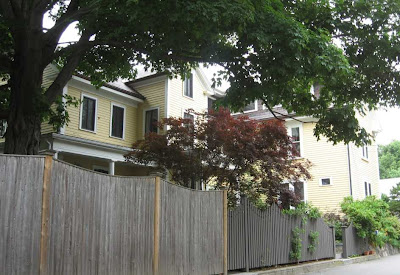 27 Eliot street - around 1850.

146 Forest Hills street - 1852.

11 Harris avenue - 1850s.

83 Elm street - 1854-55.

9 Harris avenue - between 1850-1858.
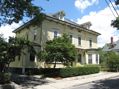 16-18 Harris avenue - 1852-1859.
 1-2 Greenough park - front, 1856; back, later addition.

793 Centre street - 1854-59
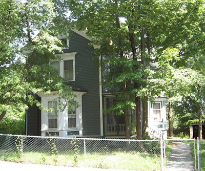
252 Chestnut avenue - probably by 1858.

6 Marlou terrace - by 1858.
 11 Newsome park - by 1859.

195 Chestnut avenue - 1858-59.

268 Chestnut avenue - probably by 1858; by 1866.
 253 Lamartine street - between 1858-1871.

17 St John street - between 1849-1856.

101 McBride street - around 1864.
 7 Revere street - 1865-1866.
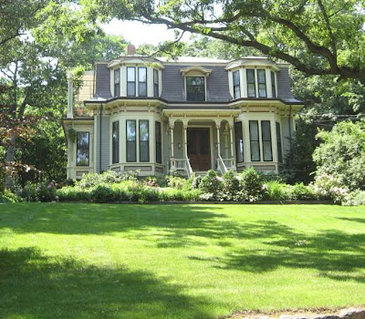 233 Chestnut avenue - possibly by 1867; by 1871

41 Clive street - between 1866-1877.
 223 Chestnut avenue - by 1868.

244 Chestnut avenue - probably by 1865; by 1871.
 61 Pond street - between 1859-1874.

9 Myrtle street - 1859-1863.

8 Myrtle street - 1859-1863.
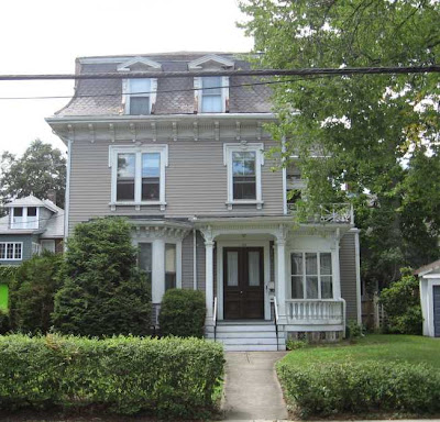
22 Orchard street - between 1859-1874.

57 Orchard street - between 1859-1874.

45 Orchard street - betwen 1859-1874.

21 Myrtle street - 1859-1874.

18 Myrtle street - 1859-1874.

11 Myrtle street - 1859-1874.

180 Moss Hill road - 1855-1874.

85 McBride street - 1866-1874.
 88 Seaverns avenue - around 1870
 84 Seaverns avenue - around 1870.
 90 Seaverns avenue - around 1870.

73 Elm street - around 1875.
 5 Eliot street - between 1859-1874.
 28 Eliot street - between 1874-1884.
 7 Eliot place - by 1875.
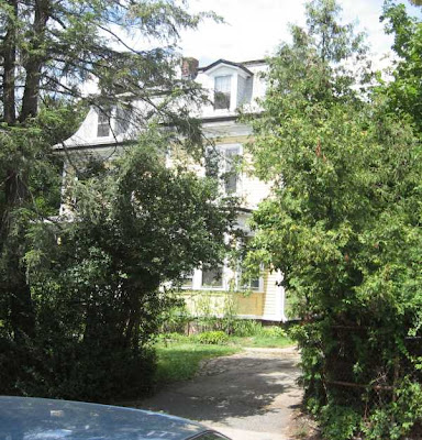 15 Custer street - between 1859-1874
 145 Chestnut avenue - by 1872.

803 Centre street - between 1871-74

271-273 Chestnut avenue - by 1874.
Note: You can see these and many more pictures of pre-20th Century Jamaica Plain houses at the J.P. Historical Society web site here.

Loring-Greenough House - 1760

1085 Centre street - by 1796

526 Centre street - by 1806

812-814 Centre street - between 1802-1810

1090 Centre street - 1820s
 48 Goldsmith street - probably pre-1830; moved from another location.
52 Eliot street - 1822-1843.
 50 Eliot street - between 1822-1843.
991 Centre street - by 1832, possibly 18th century.

1011 Centre street - by 1832.
 1 Dane street - 1833-1834.
 800 Centre street - by 1847
 45R Green street - around 1842.
 33-35 Green street - 1840-41.
 47 Eliot street - by 1843.
 305 Chestnut avenue - 1844-48.
63 May street - 1840s.
 5 Eliot place - between 1843-1854.
 20 Seaverns avenue - 1845-1846.
 18 Seaverns avenue - 1845-1846.
 14 Seaverns avenue - 1840-1845.
 28 Lakeville, between 1842-1845.
317 Lamartine street - between 1843-1858.

28 Cheshire street - between 1849-58.

242 Pond street - between 1849-1859.
 85 May street - between 1848-1859.
 27 Eliot street - around 1850.
146 Forest Hills street - 1852.

11 Harris avenue - 1850s.

83 Elm street - 1854-55.

9 Harris avenue - between 1850-1858.
 16-18 Harris avenue - 1852-1859.
 1-2 Greenough park - front, 1856; back, later addition.
793 Centre street - 1854-59

252 Chestnut avenue - probably by 1858.

6 Marlou terrace - by 1858.
 11 Newsome park - by 1859.
195 Chestnut avenue - 1858-59.

268 Chestnut avenue - probably by 1858; by 1866.
 253 Lamartine street - between 1858-1871.
17 St John street - between 1849-1856.

101 McBride street - around 1864.
 7 Revere street - 1865-1866.
 233 Chestnut avenue - possibly by 1867; by 1871
41 Clive street - between 1866-1877.
 223 Chestnut avenue - by 1868.
244 Chestnut avenue - probably by 1865; by 1871.
 61 Pond street - between 1859-1874.
9 Myrtle street - 1859-1863.

8 Myrtle street - 1859-1863.

22 Orchard street - between 1859-1874.

57 Orchard street - between 1859-1874.

45 Orchard street - betwen 1859-1874.

21 Myrtle street - 1859-1874.

18 Myrtle street - 1859-1874.

11 Myrtle street - 1859-1874.

180 Moss Hill road - 1855-1874.

85 McBride street - 1866-1874.
 88 Seaverns avenue - around 1870
 84 Seaverns avenue - around 1870.
 90 Seaverns avenue - around 1870.
73 Elm street - around 1875.
 5 Eliot street - between 1859-1874.
 28 Eliot street - between 1874-1884.
 7 Eliot place - by 1875.
 15 Custer street - between 1859-1874
 145 Chestnut avenue - by 1872.
803 Centre street - between 1871-74

271-273 Chestnut avenue - by 1874.
Subscribe to:
Posts (Atom)